Map Graph

Geographic center of the United States

Central location of the 48 or 50 states

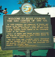
The geographic center of the United States is a point approximately 20 miles (32 km) north of Belle Fourche, South Dakota at 44°58′2.07622″N 103°46′17.60283″W. It has been regarded as such by the United States Coast and Geodetic Survey and the U.S. National Geodetic Survey (NGS) since the additions of Alaska and Hawaii to the United States in 1959.

Read article
File:UScenter2020.pngFile:Belle_Fourche.jpgFile:COs_at_marker_for_Geographic_Center_of_U.S._(13722534983).jpgFile:LebanonMarker1.JPGFile:48states_plaque.jpgFile:Monument_at_the_Geographical_Center_Of_The_US_48_contiguous_States.jpg
Top Questions
AI generated

List the top facts about Geographic center of the United States

Summarize this article

What is the single most intriguing fact about Geographic center of the United States?

Are there any controversies surrounding Geographic center of the United States?

More questions